

Boston bike tours provide you with a unique way to see the city, get some exercise, and have fun.
If you're visiting, you'll appreciate how easy exploring the city on two wheels can be, especially if you go on one of the popular guided trips that double as a sightseeing tour.
Even better, you'll get get to see some unique areas you might otherwise miss.
Our Picks for Exploring Boston by Bike
Choose a regular bike or an electric bike for these fun tours:
- City View Bike Tour - Get a fantastic intro to Boston on this family-friendly bike tour
- Guided Bike Tour of Cambridge - See Harvard Square, MIT, & lots more
Whether you're touring Boston in a group or on exploring your own, here's all the cycling tour info you'll need, including information about where to find bike tours and Blue Bikes, Boston's affordable bike-share program.
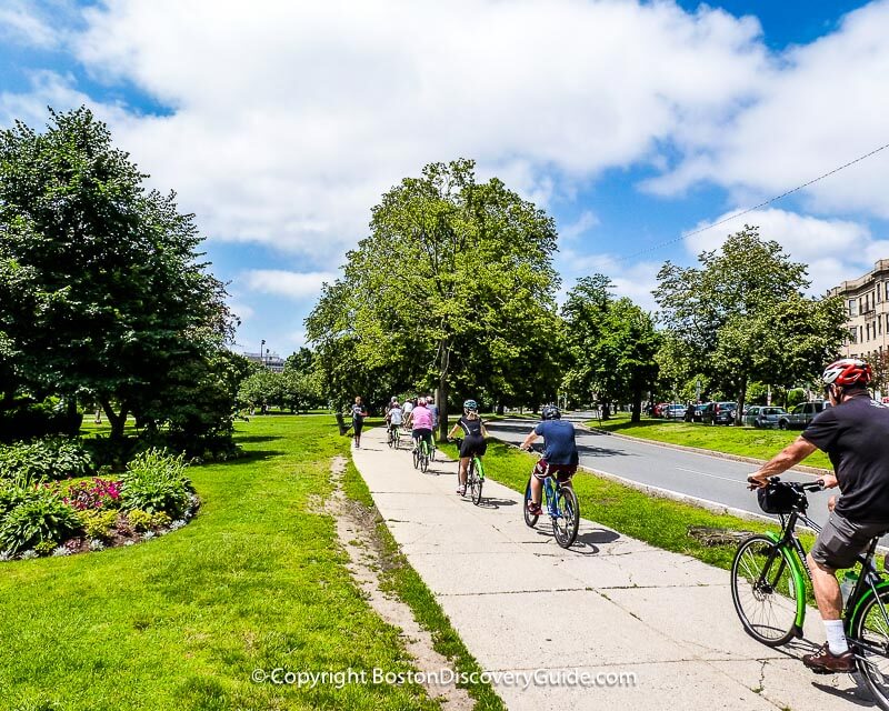
Top photo: Bike tour on Boston Common, (c) Boston Discovery Guide
Boston Discovery Guide is a reader-supported publication. When you buy through our links, we may earn a commission at no additional cost for you. Learn more
Guided Boston Bike Tours
If you're visiting Boston and want to combine sightseeing with a bike tour, the City View Bike Tour led by a professional guide from Urban AdvenTours can be the best way to see many of Boston's major sights along with charming local neighborhood streets.
You'll be amazed by how much territory you cover on these guided bike tours of Boston - the Italian North End, Fenway Park, the Esplanade along the Charles River, Beacon Hill, the Greenway, Copley Square, and everything in between!
Don't worry, though - tours are designed for all ages and skill levels, plus most of Boston is as flat as a pancake, so riding is easy.
What really makes these tours memorable is learning about the city from a professional bike tour guide who knows it inside and out.
You'll stop at all the main attractions along the bike tour route, and your guide will tell you all about the site and surrounding neighborhood. It's the best way to get introduced to the unique charms of each part of Boston.
Signing up for a tour is easy. You can book online, and when you arrive for the tour, you'll be fitted for a bike and helmet. Your guide will even give you a water bottle for the trip.
Find more about about City View Bike Tours
Touring Boston by Bike on Your Own
If you decide to tour Boston by bike on your own, you'll need to rent a bike, unless you're bringing one with you.
Where you rent your bike depends on how long you'll want to use it and how much comfort and ease of use you want.
For a full day (or even an hour or two) bike rental, high-quality, lightweight, and comfortable bikes from UrbanAdvenTours come in a wide range of sizes and gear options, and will give you a great ride.
As a bonus, your bike rental includes a helmet, a handlebar bag, a lock, lights, and a map.
The bikes are well-maintained, and the friendly staff at UrbanAdvenTours will help you pick out a bike you like in the right size.
For just an hour or less, your cheapest option will be a Blue Bike - Boston's current bike share program. You'll see the racks with available bikes all over the Boston metro area.
The Blue Bikes are convenient for short runs from one place to another. For longer stretches and self-guided tours, you may be happier with one of the more comfortable and better-maintained UrbanAdvenTour bikes.
From a safety perspective, you'll need to get a helmet, as none are available at the Blue Bike racks. Most CVS and Walgreens in the city sell them for about $15-$20.
(Wondering if you really need a helmet? Don't even think about not wearing one - Boston drivers are CRAZY! Read our driving tips to understand what bikers and pedestrians are up against! Sadly, Boston has what feels like more than its share of ghost bikes, marking the spots where fatal accidents occur.)
Also, be aware that the Blue Bikes are meant for very short-term rentals - beyond that, costs can escalate quickly. If you're planning to ride for more than a couple of hours, you'll probably save money by getting your wheels at a bike rental shop.
Boston Bike Events - Hub on Wheels

Boston's biggest bike event takes place back-to-back on a September weekend, and for fans of 2-wheel touring, it's a chance to enjoy city cycling without having to compete with cars for space on the roads.
On Sunday, Hub on Wheels takes over the city, shutting down Storrow Drive. You choose from a 10, 20, or 50 mile bike course, and you're guaranteed to see Boston from a unique perspective.
After the race, participants gather at City Hall Plaza to enjoy pop-up beer gardens and food trucks.
Check the September Events Calendar for dates/times and more info.
Essentials: Biking in Boston
- Bike lanes - They are present in a growing number of streets in the city, but because of our congested traffic, don't imagine you'll share a bike lane only with other bikes. Some drivers use these lanes for passing, turning, and parking. Also, what appear to be bike lanes in some places are also legitimately car lanes. Some of these lanes are divided, with a section for bikes and a section for cars - but here's the catch: the car lanes are too narrow for some vehicals, plus some drivers think that both lanes are for them. Expect to feel confused; plan to be super-cautious. (And wear a helmet!)
- Helmets - Bring one if you're planning to rent a Blue Bike.
- Car doors - Expect them to open unexpectedly just as you're passing by. Just because it's wrong doesn't mean it won't happen.
- Bike racks - You'll also see these in some areas - but don't count on finding one wherever you happen to be when you need one.
- Right of way - If you're riding a bike and find yourself in a situation where you need to know whether a car, bike, pedestrian, or anything else that's moving such as a Segway or scooter has the right of way, don't bother wondering what the law is, as no one else is like to know it. Just assume that you don't have it, and get out of the way. The #1 rule you need to remember for biking in Boston is Be Careful!

More Ways to Tour Boston
Check Out More Top Boston Events Each Month
January | February | March | April | May | June | July | August | September | October | November | December | Year at a Glance
- Boston's Hop-On Hop-Off Trolley Tours
- Duck Tours of Boston
- Harbor Cruise Sightseeing Tours
- Best Boston Tours for Teens
More Articles about How to Tour Boston
Need a Boston Hotel or Apartment?
Use this handy map from Booking.com to find the perfect place to stay. Just enter your dates to find what's available, see the best rates, and make your reservations.


